Mr.Winder
Veteran
- Joined
- Sep 25, 2017
- Messages
- 25
- Age
- 26
- Location
- Mantorville
- Country
- USA
- Snowmobile
- 2017 Yamaha Sidewinder
I'm going out west for the first time and I'm curious what GPS you guys recommend and what features they need to have on them?

biffdotorg
VIP Member
- Joined
- Dec 2, 2008
- Messages
- 2,158
- Location
- Pelican Rapids, MN
- Website
- www.biff.org
- Country
- USA
- Snowmobile
- Apex XTX and Viper LTX SE
- WEBSITE
- www.biff.org
Find the maps you want to use first, then what GPS brand/models are supported. What you will find is that most of the Garmin models are supported by the map makers. If you are downloading trail maps from the DNR, or other state resource, you will find the Garmin models will import those with free utilities.
There are plenty of good models, and most of it has to do with how big of a screen you want, and how you want to mount it. Some like to have the super small units. I, on the other hand, like the big screen of the Nuvi dash units. They are not weather proof, but that is no issue in the years I have used them. Run power to the sled, as most of these will have a battery that will die in the cold.
Good luck!
Carla 123
TY 4 Stroke Junkie
- Joined
- Feb 27, 2017
- Messages
- 523
- Location
- Lester beach
- Country
- Canada
- Snowmobile
- 2015 viper xtx boosted
17 zr9000 precision stage 3
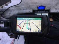
I like the Garmin montana

FrozenTows4
Lifetime Member
- Joined
- Nov 6, 2014
- Messages
- 487
- Age
- 65
- Location
- Brainerd Minnesota
- Country
- USA
- Snowmobile
- 2014 XF7000 Sold
2017 ZR6000RS
2018 ZR6000 El Tigre
- YOUTUBE
- FrozenTows1
Yep, Garmin Montana. Daylight viewable screen, water proof, takes the cold well, can take AA batteries if needed, nice screen size, accepts a variety of maps, can get slapped around and still take it.I like the Garmin montana
Mr.Winder
Veteran
- Joined
- Sep 25, 2017
- Messages
- 25
- Age
- 26
- Location
- Mantorville
- Country
- USA
- Snowmobile
- 2017 Yamaha Sidewinder
Do you need to buy a map for riding off trail? Or will the breadcrumb feature work to get you back? If I do want to buy a map where is the best place to get them?
FrozenTows4
Lifetime Member
- Joined
- Nov 6, 2014
- Messages
- 487
- Age
- 65
- Location
- Brainerd Minnesota
- Country
- USA
- Snowmobile
- 2014 XF7000 Sold
2017 ZR6000RS
2018 ZR6000 El Tigre
- YOUTUBE
- FrozenTows1
The Garmin will track, wherever you go, off trail or on with just the base map included with the unit.Do you need to buy a map for riding off trail? Or will the breadcrumb feature work to get you back? If I do want to buy a map where is the best place to get them?
But it's nice to know where the trails are. I've been using Red Pine Mapping for years.
https://redpinemapping.com/collections/frontpage
Their stand alone map is very good. It also has an overlay feature that can be displayed on top of a topo or lake map.

Mr.Winder
Veteran
- Joined
- Sep 25, 2017
- Messages
- 25
- Age
- 26
- Location
- Mantorville
- Country
- USA
- Snowmobile
- 2017 Yamaha Sidewinder
Is there a Montana trail map? I'll be going to Cooke City. I seen under your link there was no maps for Montana.
customnytromtx69
Pro
I have 2 . I take my gpsmap 62 in my pocket with me all the time In case a snowstorm or something flares up . My preference for everyday riding or I need it to get somewhere I have my gpsmap 476 (currently discontinued ) but they have a newer version the 276cx . Reason I like it and it’s the go to gps for cains quest racers is that it’s push button (touch screens get finicky in extreme cold) large screen and durable as hell
ToddMeister
VIP Member
- Joined
- Jun 30, 2003
- Messages
- 225
- Location
- Bay City, MI
- Country
- USA
- Snowmobile
- Yamaha SR Viper LTX LE
- YAHOO
- tmeister73
biffdotorg
VIP Member
- Joined
- Dec 2, 2008
- Messages
- 2,158
- Location
- Pelican Rapids, MN
- Website
- www.biff.org
- Country
- USA
- Snowmobile
- Apex XTX and Viper LTX SE
- WEBSITE
- www.biff.org
Do you need to buy a map for riding off trail? Or will the breadcrumb feature work to get you back? If I do want to buy a map where is the best place to get them?
This depends on where you ride. As FrozenTows said above, in MN Redpine works great. Others have found that VV Mapping works. And even more, many are downloadable from the state for free if you know how to load them. That is for MN.
When we were in Wyoming, there were no maps of the trails available, as 95% of the riding was off trail. So very few create maps for these areas. We came to find the roads were converted to trails once they stopped plowing. And as mentioned, they will all leave a breadcrumb trail and help you get back.
Find the map for your area, or a topo map that shows elevations. Then buy the GPS with the screen size and features that are important to you.
Similar threads
- Replies
- 4
- Views
- 3K
-
This site uses cookies to help personalise content, tailor your experience and to keep you logged in if you register.
By continuing to use this site, you are consenting to our use of cookies.