Grassfirebob
Pro
I don't know squat about portable GPS's. Who has them? Where do I get started? How/where would I find snowmobile trail information to load into it? Cost?
Thanks!
Bob "Last time I'll get lost in the trail"
Thanks!
Bob "Last time I'll get lost in the trail"
SoCoRX1
TY 4 Stroke Guru
I have a Magellan Meridian Gold GPS. People say "oh garmin i love garmin, garmin rocks" but truth is, in the trees, the magellan will get satellites and the garmin wont. The magellan gets so many more satellites than my friends Garmin E trex. I spent 200 dollars on mine and bought a Mapsend Topo program for it, so i have all the topogrophy for the entire US loaded onto it.
I really love it. Just search for "GPS Comparison" on google and thats how you get started. On the GPS manufacturer website, they have programs for people like you who want snowmobile maps.
I really love it. Just search for "GPS Comparison" on google and thats how you get started. On the GPS manufacturer website, they have programs for people like you who want snowmobile maps.
Tork
TY 4 Stroke God
Not much for complete trail mapping until now, more on that in a minute.
The 2 bigger manufacturers are Magellin (sp?) and Garmin.
Units might range from $100 or so up to $700 + actually some can even be higher. I have 3 Garnin units. The one I use mostly is my Street pilot III with a big color screen. It has every road in it, all the lakes rivers and rr tracks etc. It even has a few trails but very few. It also has 'points of interest' so I can find a selection of nearby gas stations, places to eat, lodging, shopping, you name it. key in an address and it will take you there, even give you voice prompts, but that would be by road, not by trail.
One that is better is the 276c, it has an even bigger color screen that wont wash out in bright sunlight. It also has mapping, which is the ability to save your route to memory. Move up to the 376c and you also get sat radio and you can get live weather broadcasts complete with graphics and live radar feeds.
Bob, go to the garmin and magellin sites and read up, set a budget and we can help further.
Oh....back to the begining, there was a company at the Milwaukee show that has downloadable maps of the complete trail system for northern WI and the UP, they said it costs around $100


This is a good unit also the explorist are easy to use and set up.
http://www.ty4stroke.com/viewtopic.php? ... sc&start=0
http://www.ty4stroke.com/viewtopic.php? ... sc&start=0
MOTOWN SPEEDFREEK
TY 4 Stroke Junkie
Sled Dog said:This is a good unit also the explorist are easy to use and set up.
http://www.ty4stroke.com/viewtopic.php?t=
17167&postdays=0&postorder=asc&start=0
Im with sleddog, this is going to be my first unit.GREAT PRICE!!!

QCRider
TY 4 Stroke Master
- Joined
- Feb 27, 2004
- Messages
- 1,032
- Reaction score
- 2
- Points
- 0
- Location
- Seacoast Region, New Hampshire
- Website
- www.myspace.com
I have a Garmin GPSMAP 76CS, and love it. I have never had an issue with picking up satellites in the woods. I would definitely make sure that it has a TFT screen on it as sunlight only makes the image better with this setup. Memory and the ability to store a lot of tracks and waypoints and maps is a big part of why I got this unit. They are not cheap though. Not sure what they cost now, but it was about $600 with all the software needed and accessories.
joel0920
Veteran
- Joined
- Dec 1, 2005
- Messages
- 49
- Reaction score
- 1
- Points
- 366
- Location
- Sweden Lulea
- Website
- www.elvelin.se (soon)
I can recommend Garmin 276C
it has a great display for reading at full speed (have it mounted above the instruments on a Venture)
It has a power cable for plugging directly in to 12v
it has great maps (for sweden at least) can be downloaded from internet
it can take the cold and snow (vater proof)
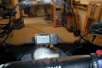
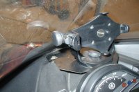
I have make a plate and bolted in original bolts on the front end and only one hole behind the instrument that is not visible..
i cant think of anything that has lifted my freride as mutch as this..
buy it and enjoy...
it has a great display for reading at full speed (have it mounted above the instruments on a Venture)
It has a power cable for plugging directly in to 12v
it has great maps (for sweden at least) can be downloaded from internet
it can take the cold and snow (vater proof)
I have make a plate and bolted in original bolts on the front end and only one hole behind the instrument that is not visible..
i cant think of anything that has lifted my freride as mutch as this..
buy it and enjoy...
Attachments
Similar threads
- Replies
- 2
- Views
- 3K
- Replies
- 2
- Views
- 2K
- Replies
- 6
- Views
- 3K