actionjack
TY 4 Stroke God
- Joined
- Apr 9, 2005
- Messages
- 2,519
- Reaction score
- 623
- Points
- 1,483
- Location
- Westminster, Maryland
- Website
- www.inspectorjack.com
- Country
- USA
- Snowmobile
- 2017 SideWinder LTX-LE
Prob aren't many people who Sled AND use a H20c. If you can see the trail maps on the device and your position you will have most of the functionality used by sledders with a GPSr. Turn by turn routing on snowmobile trails would be/is very taxing on a somewhat meager processor.
Also you might post on a site with a larger user base - here you are constrained to mostly guys on a Yamaha - reducing your subset even more. Try the HCS GPS forum although its not that active either relative to JUGGS and my-sled-is-better-than-yours threads.
Also you might post on a site with a larger user base - here you are constrained to mostly guys on a Yamaha - reducing your subset even more. Try the HCS GPS forum although its not that active either relative to JUGGS and my-sled-is-better-than-yours threads.


Blue Dave
Lifetime Member
- Joined
- Jan 7, 2008
- Messages
- 2,888
- Reaction score
- 243
- Points
- 1,453
- Location
- Ham Lake, MN
- Country
- USA
- Snowmobile
- '17 Sidewinder LTX DX
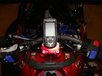
Thanks for the feedback! I think that I will try it with a temporary mounting method first to see if I like it before investing in a Ram mount. If I do not like it I can buy something better for the sled and keep using the Lowrance H2Oc just for my boat.
actionjack
TY 4 Stroke God
- Joined
- Apr 9, 2005
- Messages
- 2,519
- Reaction score
- 623
- Points
- 1,483
- Location
- Westminster, Maryland
- Website
- www.inspectorjack.com
- Country
- USA
- Snowmobile
- 2017 SideWinder LTX-LE
actionjack
TY 4 Stroke God
- Joined
- Apr 9, 2005
- Messages
- 2,519
- Reaction score
- 623
- Points
- 1,483
- Location
- Westminster, Maryland
- Website
- www.inspectorjack.com
- Country
- USA
- Snowmobile
- 2017 SideWinder LTX-LE
Blue Dave said:Thanks for the feedback! I think that I will try it with a temporary mounting method first to see if I like it before investing in a Ram mount. If I do not like it I can buy something better for the sled and keep using the Lowrance H2Oc just for my boat.
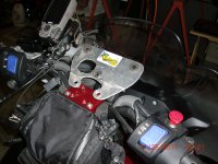
Other than the part the unit actually sits in, the cradle, the remaining parts, the ball and arms, are universal. So if you get another GPSr, you likely will only need an inexpensive cradle to adapt it to your existing RAM hardware.
Blue Dave
Lifetime Member
- Joined
- Jan 7, 2008
- Messages
- 2,888
- Reaction score
- 243
- Points
- 1,453
- Location
- Ham Lake, MN
- Country
- USA
- Snowmobile
- '17 Sidewinder LTX DX
Thanks for the additional info on the mounting! I am excited to try a GPS on the trail for the very first time. I will be testing this set-up in the Mercer, WI area next weekend!
CaptCaper
VIP Member
- Joined
- Jan 1, 2007
- Messages
- 2,295
- Reaction score
- 202
- Points
- 1,383
- Location
- Northern N.H.
- Country
- USA
- Snowmobile
- 2016 RS Vector XTX 1.25 Lug wifes..2013 RS Vector LTX.. 2003 600 VMax Past Machines 3-2007 Attaks 1-2010 Vector LTX.. sorry no Stinkdoos or poo's cats.
60CSX type are nice in functions but the screen is small. I have a 276C rugged,waterproof and can do lot's of stuff with tracks,saved or otherwise that any Nuvi can't do. I have it mounted on the riser with a Ram system..
Mikedom
Veteran
Another one for the Nuvi 500. Works great, the ram mount works great too.
biffdotorg
VIP Member
- Joined
- Dec 2, 2008
- Messages
- 2,228
- Reaction score
- 1,150
- Points
- 1,603
- Location
- Pelican Rapids, MN
- Website
- www.biff.org
- Country
- USA
- Snowmobile
- Apex XTX and Viper LTX SE
- WEBSITE
- www.biff.org
I don't have the color unit, just the Lowarance H2O. It's not turn-by-turn, but you don't use that on a sled anyway. The screen seems small, but it works in -15f without issue. It's waterproof and the ram mount is more than solid enough to mount on the handlebars.
I have found that the redpine maps are accurate enough that I can see hairpins coming up on the map quicker than in the snow dust sometimes. It's a great tool and appreciated. If I had to do it all over, I may look for something with a bigger screen, but I had the H2O and planned on using it.
I did download the free Polaris SnowTrails app for my iphone, but my waterproof iphone case just was not solid enough to mount on the sled. That and the iphone does not like the cold. It's a good reference to pull out of the pocket when needed.
Good luck!
Blue Dave
Lifetime Member
- Joined
- Jan 7, 2008
- Messages
- 2,888
- Reaction score
- 243
- Points
- 1,453
- Location
- Ham Lake, MN
- Country
- USA
- Snowmobile
- '17 Sidewinder LTX DX
biffdotorg said:I don't have the color unit, just the Lowarance H2O. It's not turn-by-turn, but you don't use that on a sled anyway. The screen seems small, but it works in -15f without issue. It's waterproof and the ram mount is more than solid enough to mount on the handlebars.
I have found that the redpine maps are accurate enough that I can see hairpins coming up on the map quicker than in the snow dust sometimes. It's a great tool and appreciated. If I had to do it all over, I may look for something with a bigger screen, but I had the H2O and planned on using it.
I did download the free Polaris SnowTrails app for my iphone, but my waterproof iphone case just was not solid enough to mount on the sled. That and the iphone does not like the cold. It's a good reference to pull out of the pocket when needed.
Good luck!
I have only tried it out at my house so far but with few snowmobile trails nearby and so many roads on the screen it was really hard to decipher. I will be testing it on the trails around Mercer, WI this weekend. I am hoping that when I get away from the cities that it will be easier to see the trails.
If you (or anyone else) have any tips on certain settings in the Lowrance menu's to make it work better for this application please PM me or call me at 612-868-7686.
Thanks,
Dave
actionjack
TY 4 Stroke God
- Joined
- Apr 9, 2005
- Messages
- 2,519
- Reaction score
- 623
- Points
- 1,483
- Location
- Westminster, Maryland
- Website
- www.inspectorjack.com
- Country
- USA
- Snowmobile
- 2017 SideWinder LTX-LE
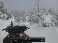
If your trail set is accurate your can almost drive by the GPS when you are zoomed in enough. You will see just your position and the trail.
biffdotorg
VIP Member
- Joined
- Dec 2, 2008
- Messages
- 2,228
- Reaction score
- 1,150
- Points
- 1,603
- Location
- Pelican Rapids, MN
- Website
- www.biff.org
- Country
- USA
- Snowmobile
- Apex XTX and Viper LTX SE
- WEBSITE
- www.biff.org
Redpine gave the best tip. On the lowrance, you can go into the trail gps settings and shut off many of the items that you don't need to see.
By default, mine were shut off, so all I saw was the trail. That served little purpose until we turned the roads, railroads and towns back on. Then the relation of trail to road or trail to town was perfect.
Then you just pick a zoom level that gives you the amount of detail you need in a timely manner.
For example, if I want to see hairpins coming up, then I am over zoomed in. If I want to get a general idea of where the next road or town is while going cross country, I may zoom out.
I had mine setup with a medium zoom and showing drainage ditches. We were flying across fields and would come up on drainage ditches at speed in flat light. That can be dangerous, so the GPS helped us there.
Good luck!
oldguy2
Pro
- Joined
- Jan 16, 2012
- Messages
- 141
- Reaction score
- 4
- Points
- 428
- Location
- Saskatchewan, Canada
- Country
- Canada
- Snowmobile
- 2010 RS Venture 2006 Apex ER
- LOCATION
- Fort Qu'Appelle
We have an H2Oc with a ram mount. I only use it to mark our trails in case we have to back track. In the summer it goes in the boat.
Blue Dave
Lifetime Member
- Joined
- Jan 7, 2008
- Messages
- 2,888
- Reaction score
- 243
- Points
- 1,453
- Location
- Ham Lake, MN
- Country
- USA
- Snowmobile
- '17 Sidewinder LTX DX
Thanks guys!
I already have a Ram mount with a suction cup for my Lowrance H2Oc that I use in my boat. Can I just replace the suction cup part with a handlebar mount and re-use the rest of the parts?
I already have a Ram mount with a suction cup for my Lowrance H2Oc that I use in my boat. Can I just replace the suction cup part with a handlebar mount and re-use the rest of the parts?
Similar threads
-
This site uses cookies to help personalise content, tailor your experience and to keep you logged in if you register.
By continuing to use this site, you are consenting to our use of cookies.