Follow along with the video below to see how to install our site as a web app on your home screen.
Note: This feature may not be available in some browsers.
We are no longer supporting TapaTalk as a mobile app for our sites. The TapaTalk App has many issues with speed on our server as well as security holes that leave us vulnerable to attacks and spammers.
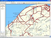
The complete version of the statewide Michigan snowmobile trails map is now ready. It's the same trail data as the trails only version I put up in December, but now it includes lakes, rivers, and roads, so it's much more useful for Garmin owners who don't have any other Garmin maps, and especially for Lowrance and Magellan users who are unable to overlay trail maps on top of other commercial maps. It's mostly made up of data from the DNR and has some extra trails that aren't in the DNR's data from other peoples' GPS tracks. The trails are all labeled with their common name, such as Pinkerton Creek Trail, Lake Superior Trail, etc.
The Garmin maps can be installed into Mapsource or uploaded to your GPS using SendMap if you don't have Mapsource. The Magellan map works on Explorist and Meridian units, as well as the Crossover. Instructions for all brands are on the download page.
This site uses cookies to help personalise content, tailor your experience and to keep you logged in if you register.
By continuing to use this site, you are consenting to our use of cookies.
!")