Silver_Ghost
Veteran
I just got back into snowmobiling after a 15 year layoff. The trail maps we use to use were basically a map with the trails drawn on them and then copied. Things have changed a little in the last 15 years. I joined my local club this year and my job is to create new maps. My plan is to ride the trails and record the GPS tracks. My question is what do I do then to create a map. I have done some research and from what I have heard the best way to create the map is to import the track data into ArcView (a software program for creating maps) the problem is the software is about $2,000. Also I would need access to the ArcGIS data which requires a subscription.
I wondering what you guys have done to create trail maps.
Oh, yea. I don't want to end up in jail by violating any copyright laws.
Thanks.
I wondering what you guys have done to create trail maps.
Oh, yea. I don't want to end up in jail by violating any copyright laws.
Thanks.
Silver_Ghost
Veteran
I guess we don't have any map makers out there.... :cry:
Roadrunner
Expert
I have a Garmin etrex Legend and with the optional Roads and Recreation Map CD ($80) I can download a trail track onto it and then print out a map.
Silver_Ghost
Veteran
Roadrunner,
Thanks for the response. I have several of the Mapsource products and I use to have a Garmin Etrex Vista. I recently bought the new Garmin 60CS, really nice unit with a color screen. I tried using the Mapsource products but it won't do the job I need to do. Mapsource looses the road detail as you zoom out. I'm looking to get all the road names and tracks on one map for the whole county.
Thanks.
airboss
Extreme
I use a Magellan Sport Track GPS unit along with Map Send software, and have had really good results for mapping.
bdm
Expert
Hey here is my very first post to your forum...
I love to use freeware called USAphotomaps by JDM Cox found at http://jdmcox.com.
I have been using it for motorcycle trail exploration for years. It automtically downloads and assembles aerial photos and topos from terraserver (also free). It transfers routes, waypoints and tracks back and forth between your computer and gps. Then you just print up any portion of the map.
Not sure if the Terraserver database covers Canada though.....
Alfo
Newbie
Hello Silver_ghost. I use Mapsource, an E-Trex and a streetpilot color and will try to do just what you want to achieve with Canada metro guide V.4 I am sure I can do it with different track savings. Have you notice that in the preferences of mapsource you can adjust the details showen on your map ?
Silver_Ghost
Veteran
Alfo,
I have the map detail set at the highest setting. The problem is when I back out the zoom to include the entire trail system I lose the smaller county roads and just end up with the major roads. I don't think this is enough detail for the map.
I just talked to a guy at the county planing office and he says the program they use is ArcView He thinks that we may be able to import waypoint and track data into his program. If the track data can be imported we should be able to lay it over a county map with all the road detail. Hopefully ArcView will allow us to print the resulting map using a large scale printer..... I hope...I hope...I hope...???...!!!
nhrxrider
TY 4 Stroke Junkie
I am a little behind the current technology, but I still have a very easy to use setup. My GPS (really the only old thing) is a Lowrance Globalmap-100 handheld. When riding I store all routes on it. Once home, or anywhere you can bring a laptop, I plug it in and use Topo! topographic map software. In the original file, you can keep track of points such as gas stops, restaurants, and other points of interest. Once uploaded to the PC software, the routes can be transfered back to GPS any time, such as summer months when trail maintenance might be going on. Of course the map can also be printed out, either in a small size on a standard printer, or you can save a copy of the entire map in .jpg format and take the disk to a printer to make up larger, professional sized copies.
After uploading to the PC, you can access info about the coordinates of any point or route. This would be good information for club web sites, since so many people use GPSs these days. People visiting the web site will be able to enter the coordinates of gas stops and other points of interest.
Jim
After uploading to the PC, you can access info about the coordinates of any point or route. This would be good information for club web sites, since so many people use GPSs these days. People visiting the web site will be able to enter the coordinates of gas stops and other points of interest.
Jim
Him
Pro
- Joined
- Mar 10, 2004
- Messages
- 182
- Location
- Sweden, the northern coast...
- Country
- Sweden
- Snowmobile
- Apex -11 MCX290
RX Warrior -04
If you have Garmin GPS, these sites below can be interesting. I have done a couple of GPS-maps of my riding area here in Sweden, it covers about 5000 km of trails.
Mapeditor:
http://www.geopainting.com/en/
Map Compiler:
http://gps.chrisb.org/en/main.htm
Other map compiler:
http://planeta.terra.com.br/informatica ... wnload.htm
This Yahoo group has some info aswell:
http://groups.yahoo.com/group/map_authors/
Mapeditor:
http://www.geopainting.com/en/
Map Compiler:
http://gps.chrisb.org/en/main.htm
Other map compiler:
http://planeta.terra.com.br/informatica ... wnload.htm
This Yahoo group has some info aswell:
http://groups.yahoo.com/group/map_authors/
bluerider
Newbie
I have been working with Map Source, USAPHOTOMAP and Delormes TOPO USA version 5. Each of these programs will allow you to upload/download and edit your tracks. Delorme's TOPO USA will print maps with grids that are useful on the trial to pinpoint your location. Each program create track files that can be shared with anyone using the same software. For example I can email a friend a track file which he can load into his GPS. I have created tracks to a desired location using USAPHOTOMAP, uploaded it to my GPS and successfully made it to the desired destination. USAPHOTOMAP is free and works well because the arial photos show the real roads and trials. No guessing if it an old grown in trail that is impassable.
WrdAl
Newbie
I use 2 diferent map programs here in Alaska. MapSource TOPO doesn't have enough information to generate detailed maps. I also use OziExplorer which I can load detailed USGS topo maps into. I use MapSource for loading the GPS, but use OziExplorer for printing out the maps with the trails I've marked.


I know where I work we use an actual sattelite pic. Go see a local surveyor about getting a sat photo. Then you can if you look close enough see the trails right on the print out. Or better ask the surveyor who may be a rider himself to transfer the gps trail onto the map. He may do it for free if he is a rider or maybe do it to support the club.
nhrxrider
TY 4 Stroke Junkie
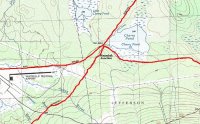
This is just a little test map to show an example of what I do with the Topo! Brand software. The trail was done freehand because I haven't been able to go for a ride (no snow) to use the GPS to plot a route, but it would look just like this...except more accurate (unsteady mouse hand!)
Jim
Jim
Attachments
Silver_Ghost
Veteran
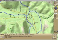
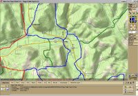
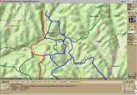
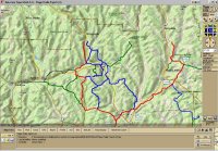
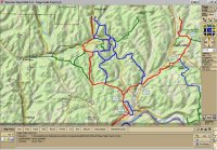
The following Images are done with Delorme TOPO 5.0
Here is a sample of what I have been playing with. See the images below... I ride the trail and record the track data into the GPS, then download into TOPO 5.0. TOPO has a pretty good edit capability as you can see in the images. The data comes from the GPS as just black lines on the map, I have made many changes. The problem I'm fighting with, is getting the road names on the map. I have to zoom in to the 13-0 level before the local county road names show up.
Tomorrow I'm going to a groomer class and show. I will be meeting with the New York State Trail coordinator who should have more information on map creation. We are also going to discuss the procedure for GPS'ing of the trails. New York is requiring that all trails in the state be GPS'ed by 2007. This is a will be a requirement in order for the clubs to continue getting state funding for trail maintenance.
Attachments
Similar threads
- Replies
- 3
- Views
- 1K
-
This site uses cookies to help personalise content, tailor your experience and to keep you logged in if you register.
By continuing to use this site, you are consenting to our use of cookies.