
rtx moose
VIP Member
- Joined
- Jul 31, 2014
- Messages
- 1,141
- Reaction score
- 550
- Points
- 1,308
- Location
- WATERTOWN,MN
- Country
- USA
- Snowmobile
- 2017 sidewinder LTX LE,2007 RTX,2000 SRX700
I will say that I go to the U.P every year and there trail markings suck!!!!!!I have had to second guess where I am plenty of times!!!HOW HARD CAN IT BE TO CORRECTLY MARK TRAILS SO YOU DO NOT HAVE TO BREAK OUT A MAP ON EVERY TURN!!!not everyone is local!!!!

Wannaviper
Lifetime Member
- Joined
- Mar 18, 2014
- Messages
- 865
- Reaction score
- 884
- Points
- 1,128
- Location
- West Gardiner, Maine
- Country
- USA
- Snowmobile
- 2016 Viper XTX SE; 2019 Sidewinder DX LTX; 2013 Vector LTX; 2014 Viper XTX SE; 2013 SRX 120
While the clubs in my area do an incredible job, they are frequently forced to reroute trails due to logging. Usually we are riding on paper company land, and we are often miles from the closest gas. Sometimes the clubs are advised of the changes months beforehand, and other times, the changes are last minute, or even mid-season. This year, they compromised and one of our main trails was only open on weekends, with logging during the week. Our trail maps are usually out of date, and the signage is less than perfect. My GPS has saved me a few times from making mistakes that would have left me short on gas, and I am far too old for long winter walks in the woods!Uumm not sure about that cannondale. Even if you don't plan your entire trip the night before following the trail signs is still very easy in Ontario. We have stop stations all over the place showing a map of the trails with arrows "you are here"
Not disputing that a GPS is useful because they are but as an old school guy I think technology can sometimes take the fun out of figuring out your route and having to put a little effort into it.
To me that is half of the fun, but as mentioned, that's just me. Technology is moving way too fast for this old guy
Mooseman
I'm not all knowing. Post your question in forum.
- Joined
- Nov 3, 2009
- Messages
- 4,021
- Reaction score
- 1,039
- Points
- 1,733
- Location
- Greely, Ontario
- Country
- Canada
- Snowmobile
- '07 Venture MP (gone)
'07 Phazer FX (gone)
'09 Phazer GT (gone)
'10 RS Venture GT (My current ride)
'10 Nytro FX (son's)
- LOCATION
- Greely, ON Canada
I will say that I go to the U.P every year and there trail markings suck!!!!!!I have had to second guess where I am plenty of times!!!HOW HARD CAN IT BE TO CORRECTLY MARK TRAILS SO YOU DO NOT HAVE TO BREAK OUT A MAP ON EVERY TURN!!!not everyone is local!!!!
You're not the only one. Even within the same province of Ontario, you either have great signage, none at all, just plain sucks or outright wrong! We have one here at a 3 way intersection that shows multiple destinations but NO ARROWS! Really?!?
- Joined
- Jun 1, 2004
- Messages
- 7,845
- Reaction score
- 2,041
- Points
- 2,103
- Location
- sudbury on
- Country
- Canada
- Snowmobile
- 2016 apex xtx
2011 apex xtx
2009 phaser rtx/x
1997 et410t/r
1988 vk 540
You're not the only one. Even within the same province of Ontario, you either have great signage, none at all, just plain sucks or outright wrong! We have one here at a 3 way intersection that shows multiple destinations but NO ARROWS! Really?!?
i agree with mooseman. ontario signage, in my area, is way worse than mi up signage. i might have to pull out the map to reference where i am compared to where i want to go but only have had 1 signage issue in the up in years i started leading a group down there as it was marked but not as well as some of the other trails.
around here you are lucky for one sign in the corner to indicate a sharp corner in the corner.
scaryest one for me though is the pipeline trail in north bay with the stop sign at the bottom of a hill with the warning sign at the top at the end of a really nice straight stretch. blew it the 1st time i rode there, now i watch like a hawk for ones like it on trails.
rtx moose
VIP Member
- Joined
- Jul 31, 2014
- Messages
- 1,141
- Reaction score
- 550
- Points
- 1,308
- Location
- WATERTOWN,MN
- Country
- USA
- Snowmobile
- 2017 sidewinder LTX LE,2007 RTX,2000 SRX700
In minnesota there reallyYou're not the only one. Even within the same province of Ontario, you either have great signage, none at all, just plain sucks or outright wrong! We have one here at a 3 way intersection that shows multiple destinations but NO ARROWS! Really?!?
Bad..with all these local club meetings you would think it would not be as bad..
InRBigness
Lifetime Member
- Joined
- Apr 10, 2014
- Messages
- 735
- Reaction score
- 462
- Points
- 1,058
- Location
- winnipeg, manitoba
- Country
- Canada
- Snowmobile
- 2016 Viper XTX-LE w/ MPI turbo
I have a Garmin 680 and I always have it on. Our signage is fantastic in Manitoba so often there is not always a use for a GPS. However we have thousands of miles of trails and remembering to go from 62 -> 721 until 35W then south on... well you get it, it can be confusing. As Cannondale says, you can take a side trail, to another one then connect back up to something that takes you to where you want to end up because the GPS will route you.
20/80
VIP Member
- Joined
- Mar 25, 2010
- Messages
- 1,635
- Reaction score
- 1,149
- Points
- 1,328
- Location
- Nova Scotia
- Country
- Canada
- Snowmobile
- 2016 APEX LE XTX
Signage can get confusing if your new to say a certain area, I like the trail signage that when you come to a major intersection there is a huge map painted on a board pointing out that you are here on this trail system, kinda gives you reference and sense of direction.
Vmax
Expert
- Joined
- Mar 20, 2018
- Messages
- 487
- Reaction score
- 237
- Points
- 658
- Location
- Lasalle
- Country
- Canada
- Snowmobile
- 2023 ZR 6000
I just plan a destination. Use it in Offtrail mode so it makes a line as bird flies to destination. Then as I am going I look for trails and cool spots heading in the direction of destination. If one I haven’t been on I take it. Have found many really cool trails this way and lots of neat Waterfalls,Gorges etc. You can really Zoom in and see things maps don’t have.
You make a good point!
yamadoo
Yamadoo is a snowmobile ' aholic'.
- Joined
- Jun 3, 2003
- Messages
- 3,645
- Reaction score
- 1,501
- Points
- 1,753
- Country
- USA
- Snowmobile
- 15 Viper STX DX red/white- GPS and KING AIR suspension 4kmiles
13 Apex XTX 45 anniversary RED/WHITE/BLACK 3K miles
10 Vector LTX Blue 9kmiles
11 Venture GT 4k miles
86 SnoScoot(2) for grand kids
I have had signage vandalism in MN lead me to beyond my fuel comfort zone. 148 on my apex..... no other fuel in less than 60 miles..... because someone thought it cool to pull the sign up and throw it in the snow....I stuck it up after finding it-on the 3rd return to the spot. Not funny at 15 below
Wannaviper
Lifetime Member
- Joined
- Mar 18, 2014
- Messages
- 865
- Reaction score
- 884
- Points
- 1,128
- Location
- West Gardiner, Maine
- Country
- USA
- Snowmobile
- 2016 Viper XTX SE; 2019 Sidewinder DX LTX; 2013 Vector LTX; 2014 Viper XTX SE; 2013 SRX 120
Years ago, before we rode with GPS on our sleds, my friend and I came into Riviere Du Loop on a saddlebag trip well after dark, and our favorite hotel was unexpectedly full. We called from the lobby and found what was probably the last room in the city that was accessible by snowmobile. They gave us the trail number, but it was dark with blowing snow and well below zero. We found the trail and came to what we thought was a dead end three times, and turned around, but we kept coming back to the same spot. On the fourth try, I realized that a snowdrift probably had covered the trail, and I struck out across a field towards the lights in the distance, and found the trail. We rode close to 300 miles that day, and we were cold and tired, and I admit we had a fair amount of anxiety when we couldn't find our way. A GPS would have made all the difference.I have had signage vandalism in MN lead me to beyond my fuel comfort zone. 148 on my apex..... no other fuel in less than 60 miles..... because someone thought it cool to pull the sign up and throw it in the snow....I stuck it up after finding it-on the 3rd return to the spot. Not funny at 15 below
Vmax
Expert
- Joined
- Mar 20, 2018
- Messages
- 487
- Reaction score
- 237
- Points
- 658
- Location
- Lasalle
- Country
- Canada
- Snowmobile
- 2023 ZR 6000
I have had signage vandalism in MN lead me to beyond my fuel comfort zone. 148 on my apex..... no other fuel in less than 60 miles..... because someone thought it cool to pull the sign up and throw it in the snow....I stuck it up after finding it-on the 3rd return to the spot. Not funny at 15 below
Not funny at all
STAIN
Lifetime Member
- Joined
- Feb 29, 2004
- Messages
- 4,409
- Reaction score
- 3,680
- Points
- 1,713
- Location
- Vermont
- Country
- USA
- Snowmobile
- 2024 Arctic Cat Riot 9000
- LOCATION
- Vermont
I think the NS1 gauge looks like a deal.....
Sledroll
TY 4 Stroke Master
- Joined
- Dec 19, 2005
- Messages
- 1,226
- Reaction score
- 531
- Points
- 1,358
- Location
- Muskoka , Ontario
- Country
- Canada
- Snowmobile
- 2022 SRX LE
2017 SW LTX LE
is that on 201,4,6,7 or somewhere near memories ?You're not the only one. Even within the same province of Ontario, you either have great signage, none at all, just plain sucks or outright wrong! We have one here at a 3 way intersection that shows multiple destinations but NO ARROWS! Really?!?
STAIN
Lifetime Member
- Joined
- Feb 29, 2004
- Messages
- 4,409
- Reaction score
- 3,680
- Points
- 1,713
- Location
- Vermont
- Country
- USA
- Snowmobile
- 2024 Arctic Cat Riot 9000
- LOCATION
- Vermont
I just saw this new gauge at the New Hampshire grass drags.
In my opinion, this is the easily the best looking gauge ever fitted to a sled.
Easy to read, seems easy to use. Looks great. Has more features than I would use. Now to see how it works in the real world.
In my opinion, this is the easily the best looking gauge ever fitted to a sled.
Easy to read, seems easy to use. Looks great. Has more features than I would use. Now to see how it works in the real world.
1nc 2000
Lifetime Member Tim
- Joined
- Feb 26, 2010
- Messages
- 3,244
- Reaction score
- 2,681
- Points
- 1,733
- Location
- Marquette, MI
- Country
- USA
- Snowmobile
- Yamaha FX Nytro RTX SE
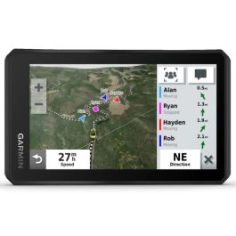
Is this new gauge the garmin tread GPS that is an accessory for our sleds from cat?
Here is the garmin tread link.
 www.countrycat.com
Here is the garmin tread link.
Arctic Cat Garmin Tread Premium GPS Kit with Radio
Only available in the USA. Cannot be shipped internationally.
www.countrycat.com
Similar threads
- Replies
- 10
- Views
- 1K
- Replies
- 4
- Views
- 4K
- Replies
- 0
- Views
- 274
- Replies
- 23
- Views
- 21K
- Replies
- 4
- Views
- 1K
-
This site uses cookies to help personalise content, tailor your experience and to keep you logged in if you register.
By continuing to use this site, you are consenting to our use of cookies.