
Doc Harley
TY 4 Stroke God
- Joined
- Oct 17, 2016
- Messages
- 3,867
- Reaction score
- 1,906
- Points
- 1,503
- Location
- Here & there
- Country
- USA
- Snowmobile
- '17 Sidewinder LTX SE
yeah it is!Have a look at next stage gauges
Very slick unit.
GPS is more of a novelty to me, that I'd sacrifice $100us For. Just to have something to play with as I ride.


snoseeker
Lifetime Member
- Joined
- Oct 9, 2005
- Messages
- 148
- Reaction score
- 53
- Points
- 1,003
- Location
- FARMINGTON MN
- Country
- USA
- Snowmobile
- just up dated to a 2017 sidewinder , 2011 xtx apex, 07 attack, 98 700 delux, 97 600 sx
- LOCATION
- minnesota
that is nice I might of gave it a try if I did not already go the other way
biffdotorg
VIP Member
- Joined
- Dec 2, 2008
- Messages
- 2,232
- Reaction score
- 1,152
- Points
- 1,603
- Location
- Pelican Rapids, MN
- Website
- www.biff.org
- Country
- USA
- Snowmobile
- Apex XTX and Viper LTX SE
- WEBSITE
- www.biff.org
I have used a couple different Nuvi's. And at the price you can find them online used, you could buy 8 of them for the price of a new waterproof one. But they work just fine. I bought a 40LM this weekend on facebook market place for $20. The LM has lifetime maps, so I updated it and it rocks. Then it just needs the Redpine Maps loaded. Now cheap RAM cradle and it's ready for a new sledder. I set them up for our sled group so they understand just how easy it is.
Emily from Redpine Mapping is a member of my Facebook group. She says new maps for 2017/2018 are in the works and should be live soon. At $29, you cannot go wrong and they are easy to load with a PC and USB cable to the GPS.
Biggest kicker, is have a 12v DC outlet available, or purchase the Garmin hardwire kit. They need power to stay lit up. And if you go with a Nuvi without the powered cradle, be sure to zip tie the power cord to the cradle so that it is not constantly whipping the power cord. It will bust the power outlet on the GPS sooner or later.
Good luck!
Doc Harley
TY 4 Stroke God
- Joined
- Oct 17, 2016
- Messages
- 3,867
- Reaction score
- 1,906
- Points
- 1,503
- Location
- Here & there
- Country
- USA
- Snowmobile
- '17 Sidewinder LTX SE
Ok, so thru Amazon I ordered......
Nuvi 5" & Ram cradle for $95.00 shipped
Red pine mapping $29.99.
Total $125.00
6" was a couple bucks more. So for those that have a hard time seeing $130?
I ran a nuvi 4.3" for years while snowmobiling. Let it in the back of my truck and broke it.
Nuvi 5" & Ram cradle for $95.00 shipped
Red pine mapping $29.99.
Total $125.00
6" was a couple bucks more. So for those that have a hard time seeing $130?
I ran a nuvi 4.3" for years while snowmobiling. Let it in the back of my truck and broke it.
actionjack
TY 4 Stroke God
- Joined
- Apr 9, 2005
- Messages
- 2,519
- Reaction score
- 623
- Points
- 1,483
- Location
- Westminster, Maryland
- Website
- www.inspectorjack.com
- Country
- USA
- Snowmobile
- 2017 SideWinder LTX-LE
Doc Harley
TY 4 Stroke God
- Joined
- Oct 17, 2016
- Messages
- 3,867
- Reaction score
- 1,906
- Points
- 1,503
- Location
- Here & there
- Country
- USA
- Snowmobile
- '17 Sidewinder LTX SE
That nice right there......
We use real Chartplotters with mapping capabilities from Lowrance. Currently we use and sell the Elite Series. 4 and 5. We also have these units on Lake County Sherriff sleds and ORV for search and Rescue. I have been working with VV Mapping since 2005 to have the best most accurate snowmobile maps in Michigan. Gps is not a novilty but really a life saving tool. I myself have been lost in a full blown Blizard while in the U P. The mapping trails guided us out and back to civilization Use your GPS as. Digital map set for North up zoom out enough to see several routes. Don’t use heading up it will confuse you as to where your going.
Offroadin
Extreme
- Joined
- Jan 17, 2015
- Messages
- 72
- Reaction score
- 17
- Points
- 418
- Location
- South of Ottawa
- Country
- Canada
- Snowmobile
- 2017 Sidewinder LTX-LE,
Woody's/BOP/UNT/Sentinel guards&LED/LinQ
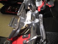
nicely done!! Is that 7/16" al? I think I am going to have to copy this......
XP123
TY 4 Stroke Master
- Joined
- Dec 25, 2016
- Messages
- 1,494
- Reaction score
- 1,440
- Points
- 1,038
- Location
- Chautauqua NY
- Country
- USA
- Snowmobile
- Sidewinder XTX LE 137
actionjack
TY 4 Stroke God
- Joined
- Apr 9, 2005
- Messages
- 2,519
- Reaction score
- 623
- Points
- 1,483
- Location
- Westminster, Maryland
- Website
- www.inspectorjack.com
- Country
- USA
- Snowmobile
- 2017 SideWinder LTX-LE
1/8” aluminum plate from Amazon. Aluminum angle is a good idea. Can prob pickup in HD or Lowes. The bracket is very sturdy.nicely done!! Is that 7/16" al? I think I am going to have to copy this......
biffdotorg
VIP Member
- Joined
- Dec 2, 2008
- Messages
- 2,232
- Reaction score
- 1,152
- Points
- 1,603
- Location
- Pelican Rapids, MN
- Website
- www.biff.org
- Country
- USA
- Snowmobile
- Apex XTX and Viper LTX SE
- WEBSITE
- www.biff.org
Do you attach the transducer, so you know how deep the water is, when it goes through the ice? I have seen plenty of guys using their Lowrance from the summer, and yes, they do attach the transducer when stopped for fishing. Nice work!
Doc Harley
TY 4 Stroke God
- Joined
- Oct 17, 2016
- Messages
- 3,867
- Reaction score
- 1,906
- Points
- 1,503
- Location
- Here & there
- Country
- USA
- Snowmobile
- '17 Sidewinder LTX SE
Where can I find a Novi powered mount for 5" screen?
biffdotorg
VIP Member
- Joined
- Dec 2, 2008
- Messages
- 2,232
- Reaction score
- 1,152
- Points
- 1,603
- Location
- Pelican Rapids, MN
- Website
- www.biff.org
- Country
- USA
- Snowmobile
- Apex XTX and Viper LTX SE
- WEBSITE
- www.biff.org
The kicker is having a Nuvi with the docking port first. Look at the bottom or backside of your Nuvi to be sure it has those connections. Most do not have it, but the ones that do, usually do have it on the dock they ship with. Some of those docks are removable.
The 7" my buddy just bought did, and that little cradle piece then attached to the RAM mount, and the usb cable plugged into that. Otherwise, there are cradles out there, just be sure your GPS can use it. For conversation sake, what model Nuvi are you trying to use?
The 7" my buddy just bought did, and that little cradle piece then attached to the RAM mount, and the usb cable plugged into that. Otherwise, there are cradles out there, just be sure your GPS can use it. For conversation sake, what model Nuvi are you trying to use?
Doc Harley
TY 4 Stroke God
- Joined
- Oct 17, 2016
- Messages
- 3,867
- Reaction score
- 1,906
- Points
- 1,503
- Location
- Here & there
- Country
- USA
- Snowmobile
- '17 Sidewinder LTX SE
Nuvi 57
Similar threads
- Replies
- 2
- Views
- 3K
- Replies
- 37
- Views
- 4K
-
This site uses cookies to help personalise content, tailor your experience and to keep you logged in if you register.
By continuing to use this site, you are consenting to our use of cookies.