rws
Veteran
- Joined
- Jan 3, 2007
- Messages
- 42
- Reaction score
- 4
- Points
- 398
- Location
- North Dakota
- Country
- USA
- Snowmobile
- 2015 Arctic Cat XF8000 SnoPro Limited
I have completed the custom Garmin trail maps for the TY Manitoba Ride.
Download here:
TY Manitoba Ride Route Maps
Please read the READ_ME_FIRST.txt file included in the zip file.
The maps install into Mapsource where you can then upload any or all of them to your Garmin GPS. The maps have a transparent background so your basemap or Topo maps will show through.
To use these maps:
1. open the zip file and extract the individual .exe route files to a folder
2. double click each route file to run the setup program...this will install the maps into Mapsource
3. open Mapsource
4. select the map(s) from the drop down Product list box
5. Use the Map Tool to select the map for upload (repeat steps 4 and 5 for each map you want to upload including Topo if you have it)
6. when you have selected all maps wanted click the Send to Device icon to upload maps to your GPS
If desired you can show/hide each individual map on your GPS to display only the map you are currently riding...see your GPS owners manual on how to do this.
Screenshot showing how trails will appear on GPS (over Topo)
Trails will be red with a black border.
blustar
Pro
- Joined
- Mar 11, 2009
- Messages
- 192
- Reaction score
- 2
- Points
- 326
- Location
- Manitoba
- Website
- members.shaw.ca
- Country
- Canada
- Snowmobile
- Yamaha Apex and RS Vector
Thanks Ross
Did you get through Maida crossing or did you have to go to Pembina?
Did you get through Maida crossing or did you have to go to Pembina?
blustar
Pro
- Joined
- Mar 11, 2009
- Messages
- 192
- Reaction score
- 2
- Points
- 326
- Location
- Manitoba
- Website
- members.shaw.ca
- Country
- Canada
- Snowmobile
- Yamaha Apex and RS Vector
Okay everyone. For those who haven't let me know yet if your confirmed, please do so for the ride starting tomorrow.
The ride will definetely not be as large as the previous ones so it will be alot easier with a smaller group.
Be ready to hit the trail at 8:30am each day, that means all gassed up etc. and be there at the front of the Glen Howard Inn in Lac du Bonnet. The reality of it is that we will likely be out by 9:00am. Before you ride, I need you to sign a waiver from TY.
The rides will likely go as follows:
Wednesday, Feb 24 - Netley Creek - 313 km
Thursday, Feb 25 - Nopiming - 246 km
Friday, Feb 26 - Falcon Lake - 315 km
Saturday, Feb 27 - 135 km (we will have a Kulbassa cookout at Kings Kookout Hut)
Hotel - Glen Howard Inn
If you need to get in touch with me, you can call me on my cell (Brian @204-793-1442 or email me at brychlicki@hydro.mb.ca anytime as I will have my blackberry on during the entire 4 days. I will be checking it periodically as well in case you need to get hold of me)
We are hoping to meet up with SwissSledders group on one of the evenings for a drink or supper if we can work it out. Those details will be finalized shortly.


Sasquatch
Lifetime Member
- Joined
- Apr 17, 2004
- Messages
- 3,699
- Reaction score
- 974
- Points
- 1,733
- Location
- North Western Ontario
- Website
- www.dptc.com
- Country
- Canada
- Snowmobile
- Yamaha's
Well I missed the first day with a broken sled and rush shipping that takes 7 days and costs 56 bucks. 
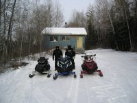
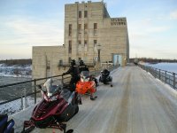
But day two was a great ride. SXTuner Bluestar and myself rode to nopoming and met up with Swiss Sledder, Bever Fever, SRX Twins, Yamadoo, NOSPRO, and the Cat guy. Can't remember his name but he followed us around on the TY ride a couple years back.
We rode with them from Nopoming to Seven Sisters then parted company and headed back to LDB. About a 210 mile day with awesome trails with only a few bad spots. Considering the poor snow conditions and bad start to winter my hats off to the people who work on the trails.
Here is a couple pics with more to follow.
Attachments

Swiss Sledder
TY 4 Stroke God
- Joined
- Apr 18, 2003
- Messages
- 2,792
- Reaction score
- 6
- Points
- 816
- Location
- Bidford on Avon, United Kingdom
- Website
- www.mi5.gov.uk
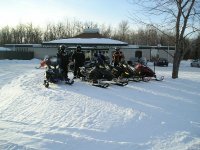
It was great riding with you guys that day. One picture from after the ride.Sasquatch said:But day two was a great ride. SXTuner Bluestar and myself rode to nopoming and met up with Swiss Sledder, Bever Fever, SRX Twins, Yamadoo, NOSPRO, and the Cat guy. Can't remember his name but he followed us around on the TY ride a couple years back.
Attachments

- Joined
- Jun 28, 2004
- Messages
- 2,436
- Reaction score
- 500
- Points
- 1,723
- Location
- Clinton, Wi.
- Country
- USA
- Snowmobile
- '11 Apex XTX, '09 Venture GT, '06 Attak, 08 Nytro Hybrid
What a rough looking crew LOL! Just wish I could have been there. My trip to Manitoba was memorable on many levels. Glad you all could make it!!
buddah
Lifetime Member
- Joined
- Apr 14, 2003
- Messages
- 1,483
- Reaction score
- 284
- Points
- 1,288
- Location
- Wetmore, MI
- Country
- USA
- Snowmobile
- '17 Sidewinder B-TX LE
Swiss Sledder said:It was great riding with you guys that day.
So now we know who NOS's NEW BFF is

So did he ever keep his nose out of the PC THIS time?
Sasquatch
Lifetime Member
- Joined
- Apr 17, 2004
- Messages
- 3,699
- Reaction score
- 974
- Points
- 1,733
- Location
- North Western Ontario
- Website
- www.dptc.com
- Country
- Canada
- Snowmobile
- Yamaha's
Sasquatch
Lifetime Member
- Joined
- Apr 17, 2004
- Messages
- 3,699
- Reaction score
- 974
- Points
- 1,733
- Location
- North Western Ontario
- Website
- www.dptc.com
- Country
- Canada
- Snowmobile
- Yamaha's
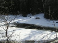
Day three, the cookout and the Ball licker radar run. Hmlrx1 clutch tuning trying to eek out a few more kms.
Attachments


Sasquatch
Lifetime Member
- Joined
- Apr 17, 2004
- Messages
- 3,699
- Reaction score
- 974
- Points
- 1,733
- Location
- North Western Ontario
- Website
- www.dptc.com
- Country
- Canada
- Snowmobile
- Yamaha's
Hlmrx1 at the Ballicker radar run
http://www.youtube.com/watch?v=aaF6EJ33JqI
SXTuner
http://www.youtube.com/watch?v=kVVlAm2aKgw
http://www.youtube.com/watch?v=aaF6EJ33JqI
SXTuner
http://www.youtube.com/watch?v=kVVlAm2aKgw
BVER FEVER
Expert
- Joined
- Apr 21, 2004
- Messages
- 310
- Reaction score
- 0
- Points
- 591
- Location
- MOSQUITO CAPITAL OF THE NORTH EH?
He never even brought his PC Buddah, he went out and got himself a crackberry before the trip.buddah2 said:Swiss Sledder said:It was great riding with you guys that day.
So now we know who NOS's NEW BFF is
So did he ever keep his nose out of the PC THIS time?
One eye was texting everytime we stopped, unless he was changing wheels for someone.
Similar threads
- Replies
- 172
- Views
- 39K
-
This site uses cookies to help personalise content, tailor your experience and to keep you logged in if you register.
By continuing to use this site, you are consenting to our use of cookies.