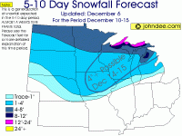
Here's the latest from John Dee:
"In any case, it looks like snows will start to break out across the eastern 2/3rds of the Dakotas, eastern NE, far NW IA and most of MN later Saturday into Saturday night. Most accumulations by Sunday morning will be in the 1-3" range.
The storm will then become better organized and the way things look right now, an area of moderate snows will fall across much of MN, northeast IA, the NW 3/4ths of WI, all of the UP and extreme NW lower MI. Accumulations in those areas look to be in the 2-6" range in most cases. An area of moderate to heavy snows is also indicated to be imbedded in the area of moderate snows and that band of heavier snow currently looks to bring the potential for 6-12" of snow to northeast MN, extreme northwest WI and the western 1/2 of the UP."
"A period of moderate to heavy lake snows will likely follow the Sunday storm and accumulations of 4-8", isolated to 10"+ are possible in the UP, with 1-4" totals in NWL MI for Monday. Tuesday sees the LES to quiet down a bit, but still continue to fall, with most accumulations in the 1-3" range. Most other areas of the Midwest will be quiet (snow-wise) for Monday and Tuesday. By later Wednesday into Thursday, a clipper type system is indicated to work from the northern Plains into the northern Midwest and currently looks to bring a general 1-4" of system snow to most of the Northwoods and will also likely ramp up the LES guns in the UP, where lake enhancement and pure LES could easily double the 1-4" seen elsewhere in the Northwoods. The LES will likely continue into Friday, with the rest of the region quiet and then by Saturday, ideas become a bit mixed. The idea I am leaning more towards calls for another low to develop in the southwest Plains and swing NE into the Midwest. This system would bringing the potential for some moderate to perhaps heavy snows (4-10") to northeast IA, SE MN, all but the far NW and SE corners of WI, the eastern 2/3rds of the UP and northern 1/3rd of lower MI. The other idea for weekend of the 15th-16th is for the bulk of the heavier precip to fall as rain and fall mainly to the south of the Midwest, with a general 1-3" of snow falling across the northern 1/2 of the region."


